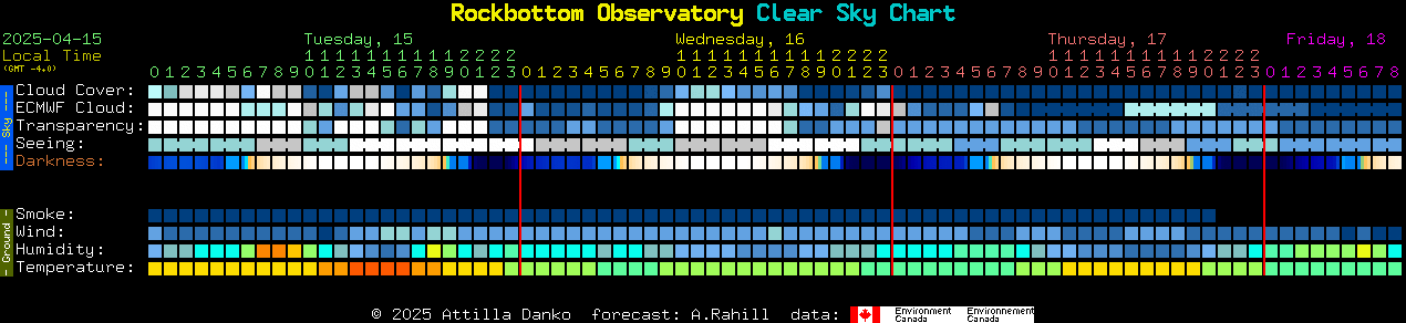
spacer
Updated: @ 23-Apr-2025 4:20am - next update at 4:25am  
Summary / Temperature Wind Rain Outlook
Night time, Dry, Clear skies Night time, Dry, Clear skies
Currently: 50.4, Max: 58.4, Min: 50.3 50.4°F
Colder 2.5°F than last hour.

---

Feels like: 50°F

24-hr difference
3.7°FWarmer 3.7°F than yesterday at this time.
  Today Yesterday
High: 58.4°F
12:00am
75.5°F
3:48pm
Low: 50.3°F
4:00am
46.7°F
3:36am
 Wind from W W
3.6
Gust:
3.0 mph
1 Bft - Light Breeze
Today: 9.2 mph 1:19am
Gust Month: 25.0 mph April 20
Rain Today: 0.00 in
Rain Rate (/hr): 0.000 in
Rain Yesterday: 0.19 in
Storm Rain: 0.19 in
This Month: 2.65 in
Season Total: 8.41 in
14 rain days in April.
Tonight

Tonight: Rain likely and possibly a thunderstorm before 10pm, then a slight chance of rain between 10pm and 11pm.  Patchy fog before 11pm.  Otherwise, cloudy during the early evening, then gradual clearing, with a low around 43. West wind 7 to 11 mph, with gusts as high as 28 mph.  Chance of precipitation is 60%. New precipitation amounts between a tenth and quarter of an inch, except higher amounts possible in thunderstorms.
Low: 43 °F
Humidity & Barometer Almanac Moon
Humidity: 59 % Increased 5.0% since last hour.
Dew Point: 36.6°F Decreased 0.1°F since last hour.
Barometer: 30.108 inHg Rising 0.01  inHg/hr
Baro Trend: Steady
Sunrise: 5:52am
Sunset: 7:37pm
Moonrise: 3:47am
Moonset: 2:36pm
Waning Crescent
Waning Crescent, Moon at 24 days in cycle
26%
Illuminated
UV Index Solar Radiation
   0.0    None
High: 0.0 @ 12:00am
0 W/m2 (0 %)
High: 0 @  12:00am
 NWS Weather Forecast  - Outlook: This Afternoon & Tonight
This
Afternoon
This Afternoon: Rain likely and possibly a thunderstorm.  Patchy fog.  Otherwise, cloudy, with a high near 65. Southwest wind around 11 mph, with gusts as high as 26 mph.  Chance of precipitation is 70%. New rainfall amounts of less than a tenth of an inch, except higher amounts possible in thunderstorms.
High: 65 °F

Rain Likely
and Patchy
Fog
NWS forecast: Rain likely and possibly a thunderstorm. Patchy fog. Otherwise, cloudy, with a high near 65. Southwest wind around 11 mph, with gusts as high as 26 mph. Chance of precipitation is 70%. New rainfall amounts of less than a tenth of an inch, except higher amounts possible in thunderstorms.
Davis VP+ forecast: Mostly clear with little temp change.
 
Tonight

Tonight: Rain likely and possibly a thunderstorm before 10pm, then a slight chance of rain between 10pm and 11pm.  Patchy fog before 11pm.  Otherwise, cloudy during the early evening, then gradual clearing, with a low around 43. West wind 7 to 11 mph, with gusts as high as 28 mph.  Chance of precipitation is 60%. New precipitation amounts between a tenth and quarter of an inch, except higher amounts possible in thunderstorms.
Low: 43 °F

Rain Likely
and Patchy
Fog then
Mostly Clear
NWS forecast: Rain likely and possibly a thunderstorm before 10pm, then a slight chance of rain between 10pm and 11pm. Patchy fog before 11pm. Otherwise, cloudy during the early evening, then gradual clearing, with a low around 43. West wind 7 to 11 mph, with gusts as high as 28 mph. Chance of precipitation is 60%. New precipitation amounts between a tenth and quarter of an inch, except higher amounts possible in thunderstorms.
Sky Cam

Rockbottom Observatory all sky cam.

Current Solar, Terrestrial, and Lunar Conditions


Clear Sky Clock


Clear Sky Clock courtesy of: Attilla Danko         Data is provided by the CMC

Click on Map Pin and get Directions to the Observatory